Yosemite National Park is the 3rd national park in USA with amazing granite cliffs, waterfalls, giant sequoia groves, glaciers, mountains and lakes. **Yosemite National Park ** is located in Sierra Nevada, California, a mountain range that stretches over 400 miles.
During our initial visit to the park we did a one day itinerary. We did a lot of research to finalize the best spots in the limited time we had, so hopefully this journal will help folks to plan their future travel.
We had an overnight stay at Fresno, CA and we did an early morning start around 6:30 from Fresno to Yosemite National Park.
Reading a lot of blogs we were undecided at first whether to visit Glacier point in the morning or evening, but since we were to hit the fork to Glacier road on our way from Fresno, we decided to visit Glacier point first. So all the pictures
We entered the main park around 9 a.m and we already had purchased our annual pass. In case you are not aware of the pass, click here to find out more that will save you a lot of money in case you are planning to visit multiple parks within one year.
Stop #1: Washburn point
Washburn point is on the way and a mile before Glacier point. Washburn Point provides a beautiful and distinct view of Half Dome. While Glacier Point is more straight on, Washburn Point is a little more to the side, so the dome is not as defined as you would expect it to be.
Washburn Point, just south of Glacier Point, has similar views, though the views of Vernal and Nevada Falls are more direct.

Stop #2: Glacier point
Glacier Point is the most famous and unobstructed viewpoint since you are practically right across from Half Dome itself. The valley that is between you provides an excellent foreground for photos as it is incredibly vast. This is the best spot for stargazing, as you can see the outline of Half Dome below the stars. It is also a trendy sunset spot where you can get great photos of the last light on top of Half Dome. Overall, it is probably the best place to view Half Dome from.
Arguably the most spectacular view in the park is at the end of Glacier Point Road, about an hour’s drive from the valley. Here you can gaze out across the Sierra Nevada high country, with the curved tooth of Half Dome prominently in the foreground.
If you walk just a short distance down the Panorama Trail, you might have this epic view, which also includes Vernal and Nevada Falls, almost all to yourself. Full moon nights are a magical time to visit Glacier Point, where John Muir and US President Teddy Roosevelt once camped out. Note Glacier Point Road is usually closed beyond the Yosemite Ski & Snowboard Area from November until late May or early June.
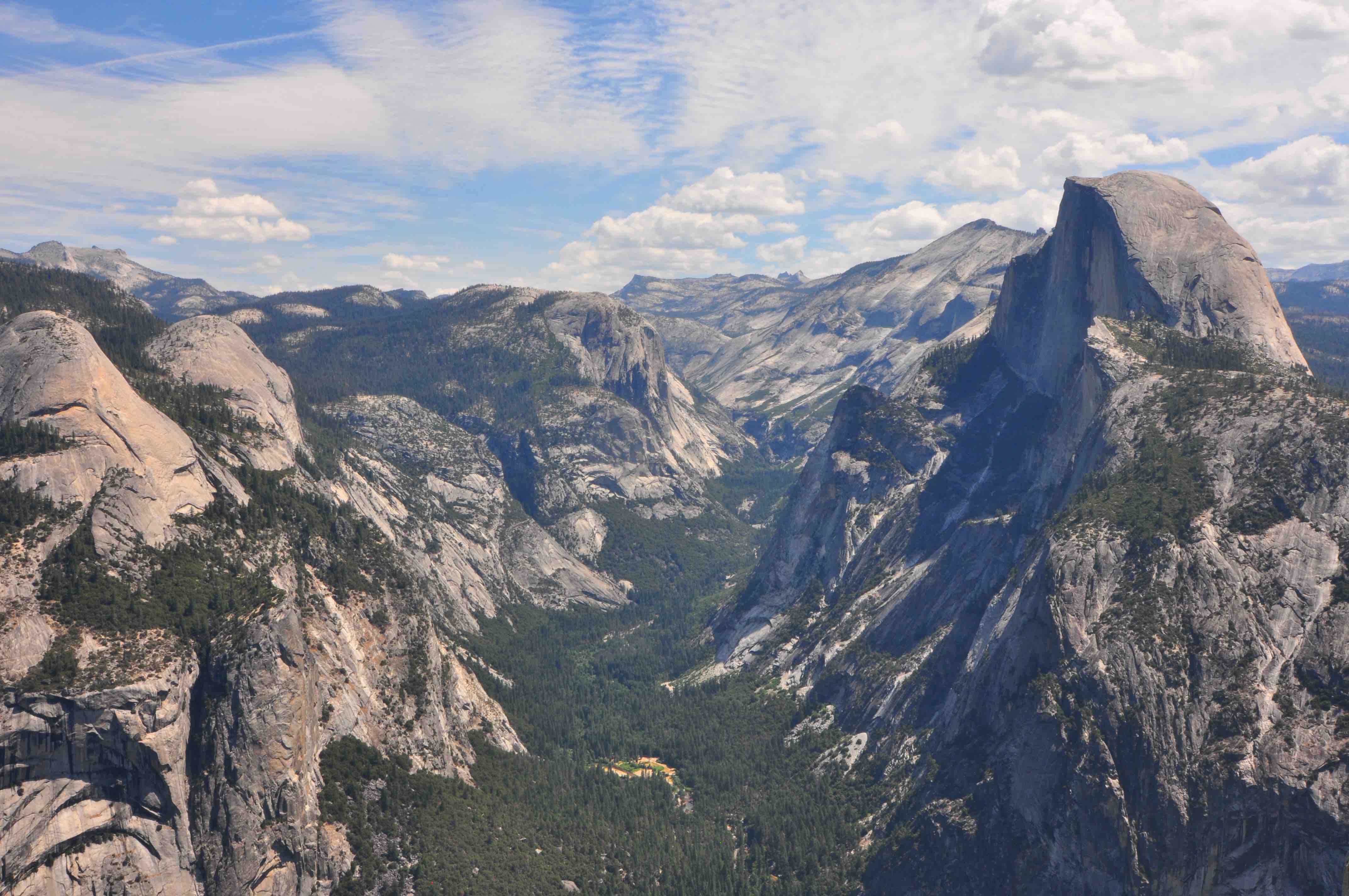
One of Yosemite’s best viewpoints is Glacier Point. Located on the south wall of Yosemite Valley, the overlook rises to an elevation of 7, 214 feet with great views of Half Dome, Yosemite Falls, Vernal Fall (a 317-foot waterfall) and Nevada Fall (594 feet).
Glacier Point’s 7,214-foot overlook provides an unforgettable vista of Yosemite Valley and the High Sierra crest. Stand at the stone walls and survey Vernal and Nevada Falls and the Merced River canyon, or walk inside the granite Geology Hut to peer out at Half Dome. Best time to visit? Sunrise or sunset, when Half Dome and its granite neighbors turn pink.
Glacier point loop
We walked around the glacier point overlook area
Stop #3: Yosemite Tunnel View
At the western entrance to Yosemite Valley, Tunnel View is a must-do stop, no matter which direction you approach the park from. You’ll find it on the east end of Wawona Tunnel along Wawona Road, which is also Hwy. 41.
Here you can take photos of the most famous panorama of Yosemite Valley, perfectly framed by a forest of pine trees and wide-open skies above. On your right is Bridalveil Fall, plunging off granite cliffs. To the left is the iconic granite rock formation of El Capitan, with Half Dome rising in the background. During peak waterfall season in May, you might spy several more short-lived lacy cascades dropping steeply off the sides of the lushly carpeted valley, too.
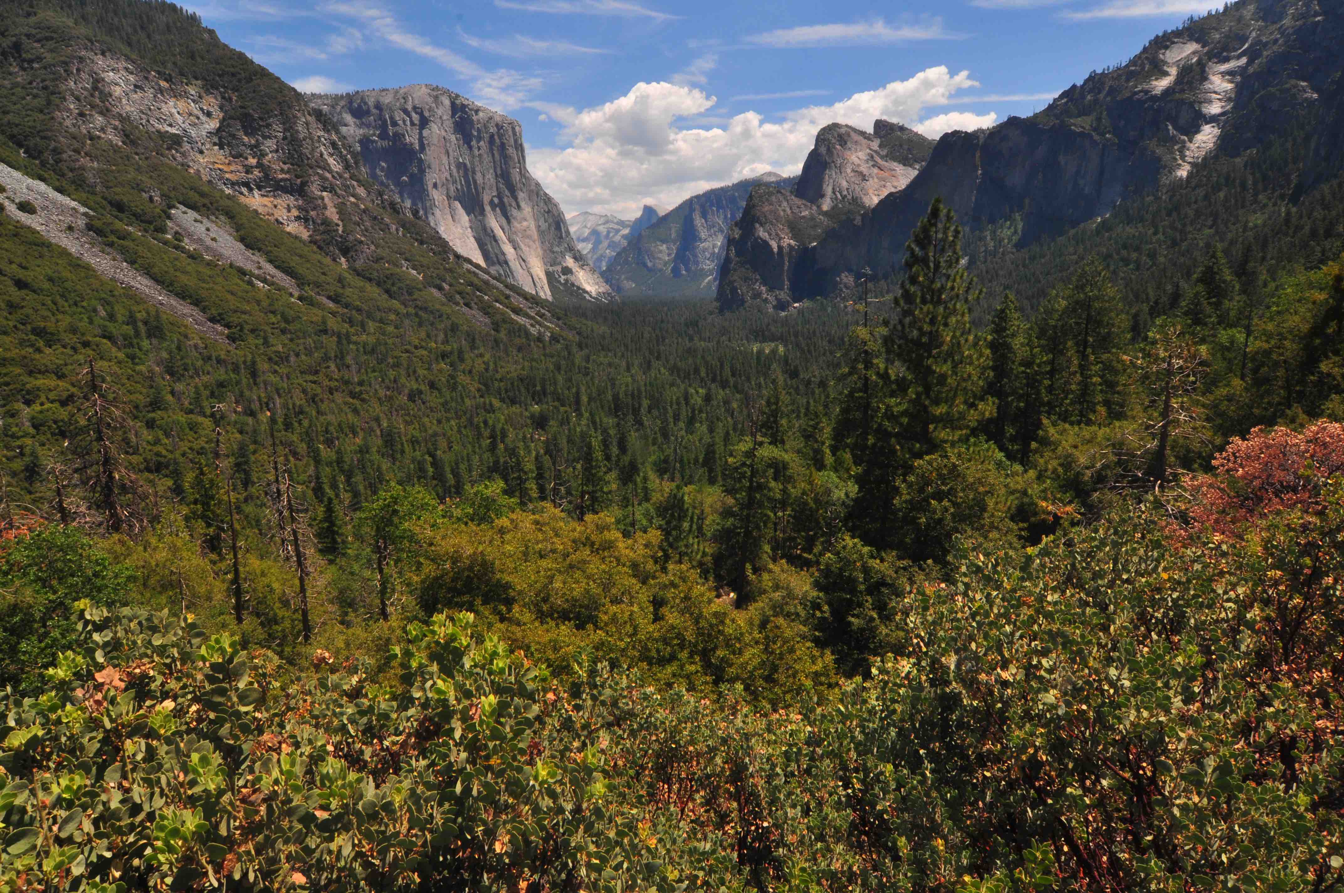
Journey along State Route 41 and you’re in for a treat: The viewpoint known as Tunnel View offers a breathtaking snapshot of Yosemite Valley and several of its attractions — El Capitan, Half Dome and the waterfall Bridalveil Fall (pictured, right).
The vista from Tunnel View is one of Yosemite’s most iconic scenes, made famous by an Ansel Adams photograph. From the Wawona Tunnel’s eastern side, shoot your own postcard-panorama of Yosemite Valley, El Capitan, Half Dome, and Bridalveil Fall. Or hike the Pohono Trail uphill for an even bigger view where you can enjoy the scenery in relative solitude.
Now we were hungry and finding parking in Yosemite is bit difficult
Stop #4: Lunch
We stopped at the Yosemite Valley Village Grill for lunch. Had a delicious pulled pork sandwich and refreshed with some drinks and then we headed to our next destinations
Stop #5: Yosemite Falls
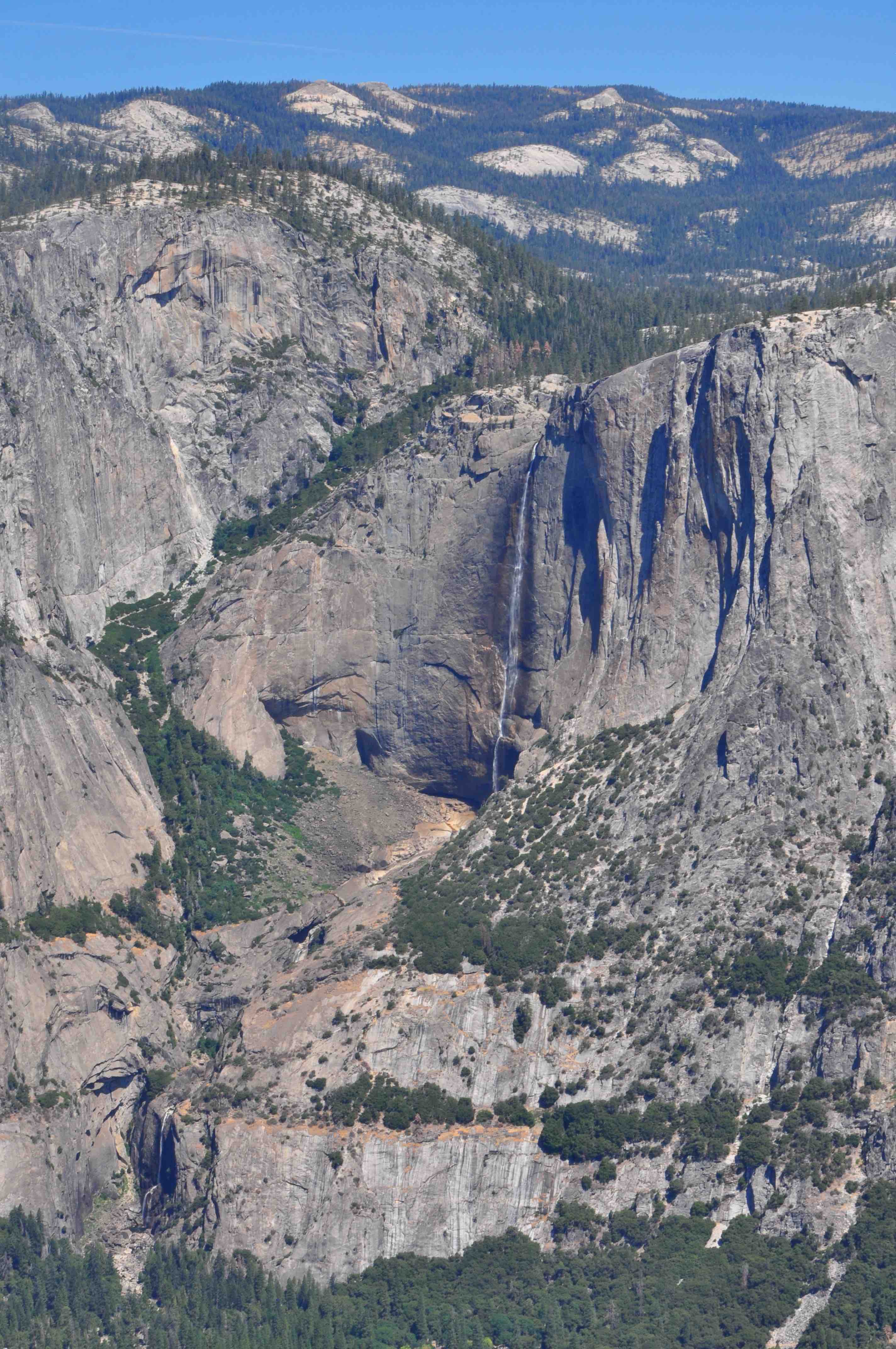
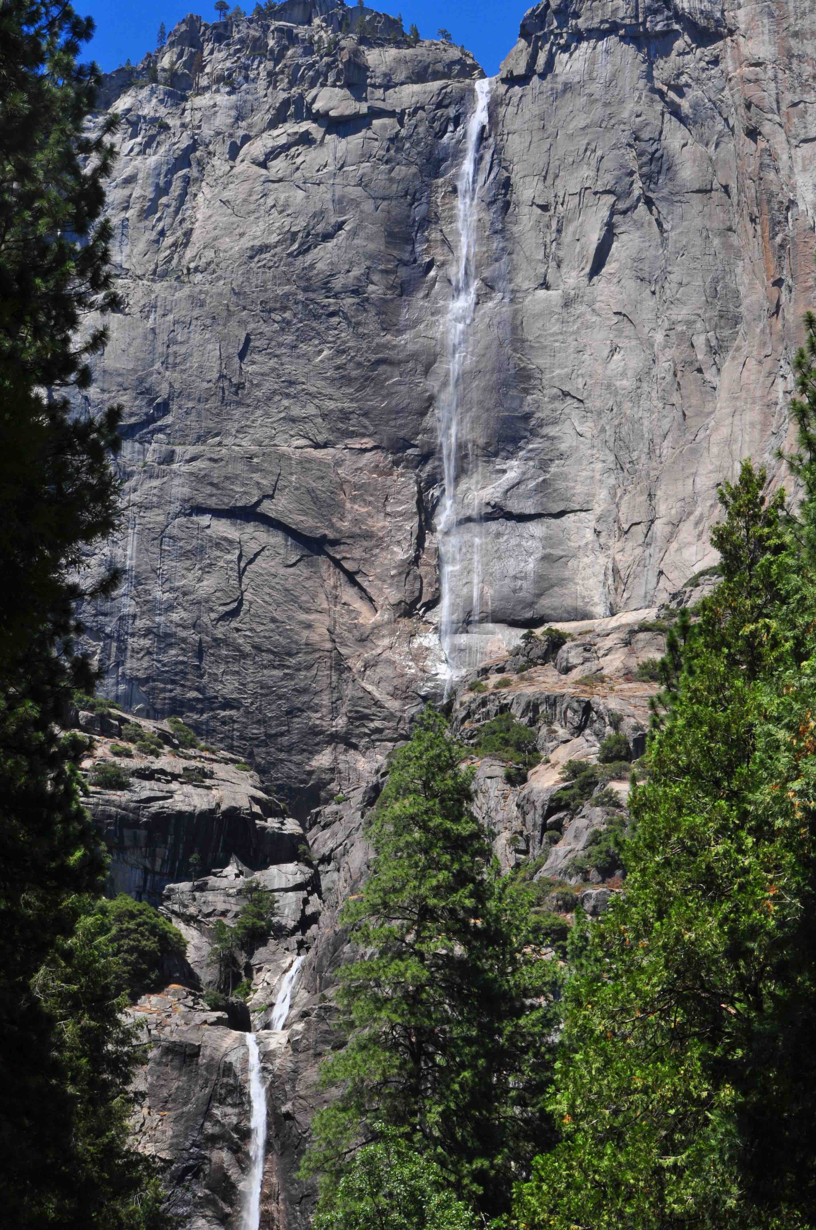
Discover the highest waterfall in North America and the sixth largest in the world: Yosemite Falls. At 2,424 feet, the waterfall is a major attraction in the park, located in the central Sierra Nevada mountain range of California. It’s best viewed in late spring when snowmelt flows most vigorously.
Upper, Lower, and Middle Yosemite Falls combined make up the highest waterfall in North America, topping out at a prodigious 2,425 feet. A challenging trail accesses the upper fall’s crest, but the base of the lower falls can be visited with an easy stroll. From April to June, wear rain gear—an icy spray drenches all who come near. A lightweight Columbia Watertight II Rain Jacket
is a good option to stay dry.
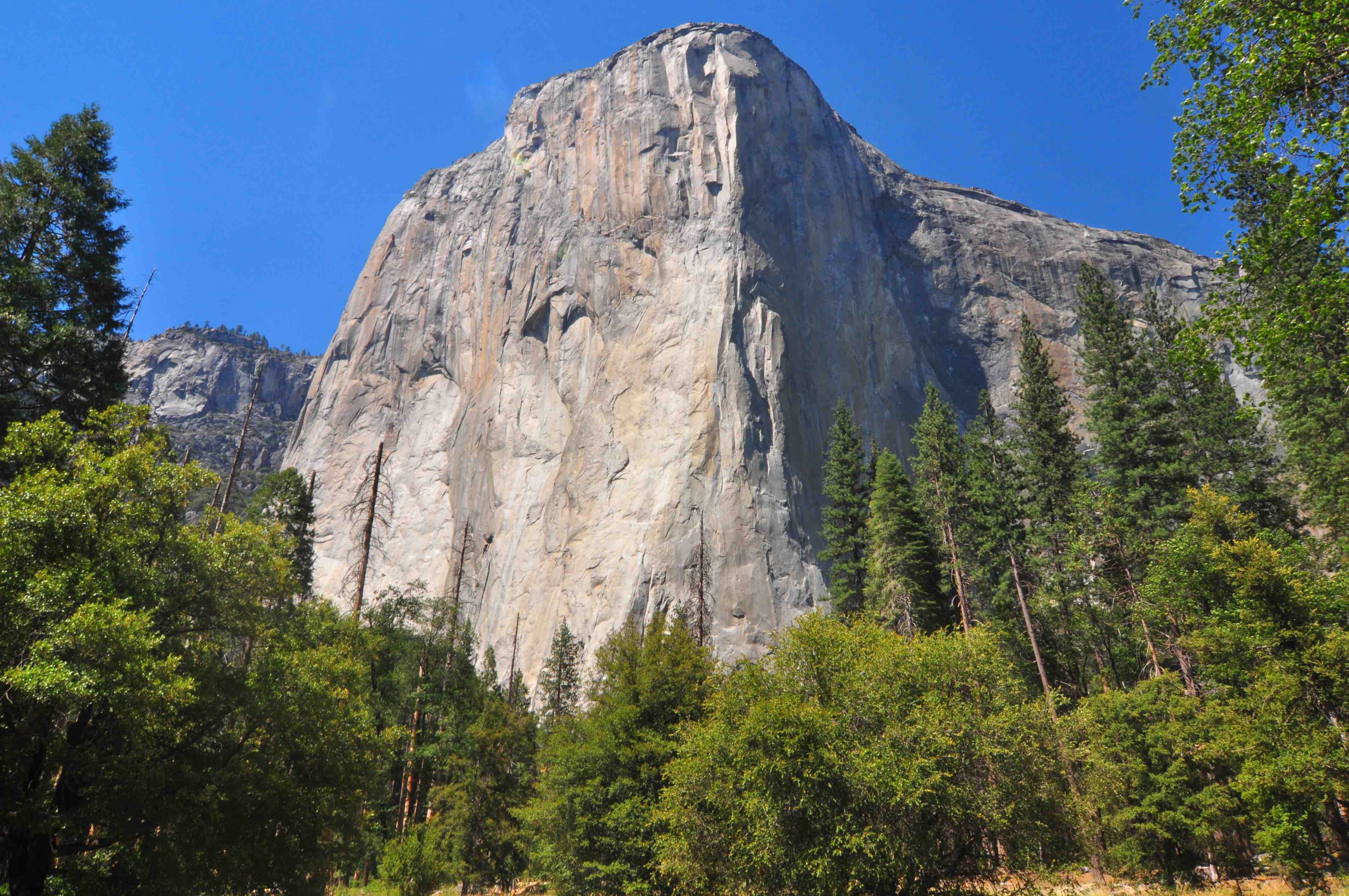
Stop #6: El Capitan Meadow
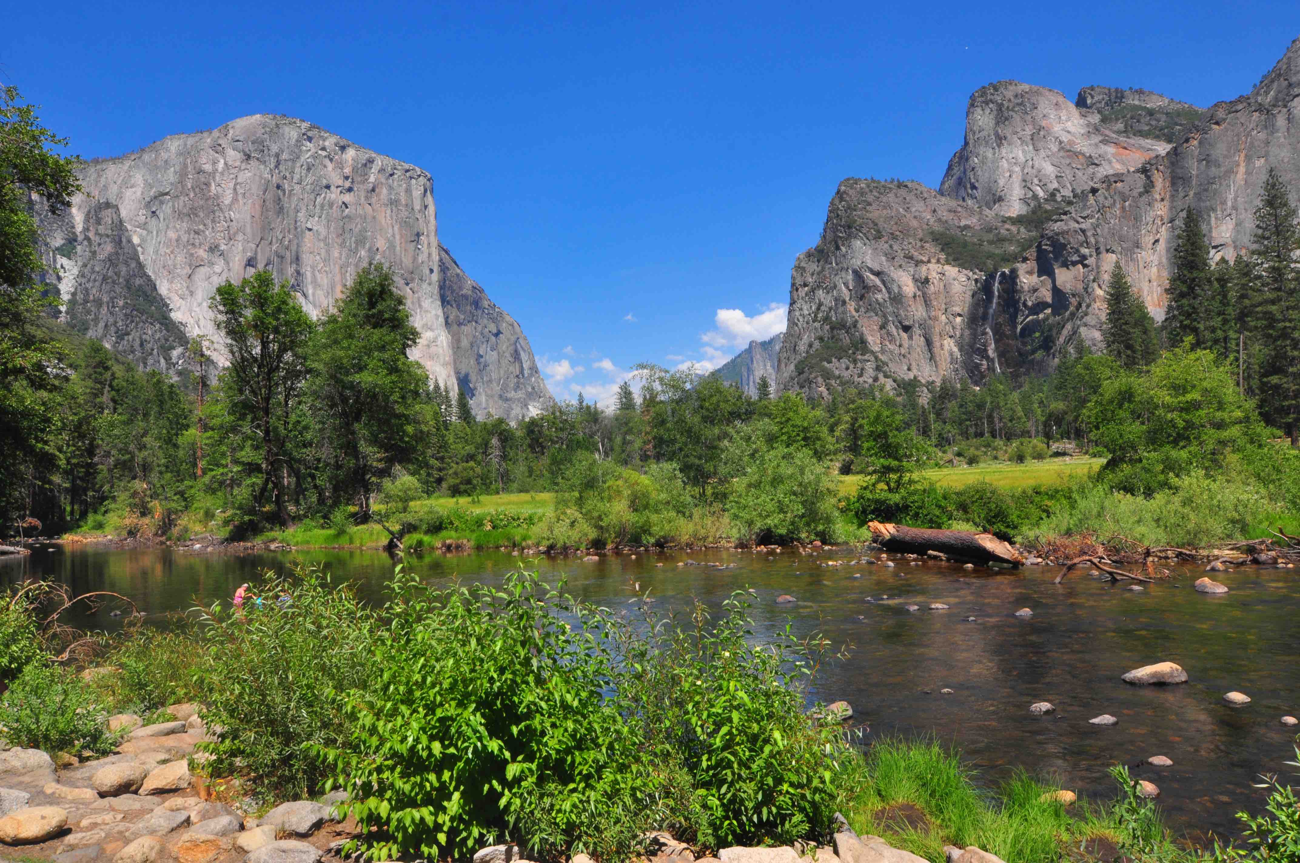
Stop #7: Yosemite Valley View
As you leave Yosemite Valley to see the Mariposa Grove of Giant Sequoias in Wawona near the South Entrance, stop at this roadside lookout along one-way Northside Drive right before you reach Pohono Bridge.
You’ll see the Merced River (something missing from the earlier Tunnel View), flanked by El Capitan, which reaches 3,000 feet up to the sky, and opposite it, the imposing Cathedral Rocks and Spires.
Rock climbers will find few vertical rock formations as challenging as El Capitan (left, background). At one time “El Cap,” which stretches roughly 3,000 feet from base to top, was considered impossible to climb. Today, the most popular route to tackle is The Nose, which follows the rock’s huge projecting front.
Thank the 145-mile-long Merced River: It’s responsible for carving out the glacial valley known as Yosemite Valley. The valley is about eight miles long and a mile deep, with an amazing vantage point offered at Valley View. This turnout is located near the park exit, traveling west on Northside Drive.
Bye bye Yosemite
We were on our way to San Francisco around 3 pm after our quick one day itinerary. I am sure we will be back in future to get some hiking trails and spend some more time in this beautiful valley. Happy travels everyone!